Image Colnect-892-532-Island-map-of-Tortola.jpg
(285 x 228 pixels) |
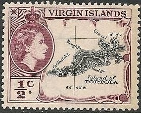
Type: stamp Issuer: Virgin Islands Date: 1956 Denom: ?
Visibility: public Image owner: none postage 11/1/1956 1/2c redpur&blk issue=1956 d=map of Tortola & Queen Elizabeth II wmk=mult crown & script CA perf=15 Crops No visible images cropped from this one. Measurements Resolution is unknown. Source Source name: Colnect File URL: http://i.colnect.net/images/b/892/532/Island-map-of-Tortola.jpg Uploaded August 18, 2014, 7:47 pm by Stan Shebs |