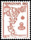
| X |
5o |
brn |
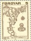
Map of Faroe Islands 1673, p. 12.75 | |
|
|
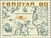
| X |
10o |
grn & bl |
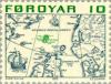
Map of Northern Europe by Abraham Ortelius, p. 12.75 | |
|
|
| X |
50o |
dkgrnbl |
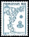
Map of Faroe Islands 1673, p. 12.75 | |
|
|
| - |
60o |
brn & bl |
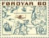
Map of Northern Europe by Abraham Ortelius, p. 12.75 | |
|
|
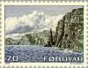
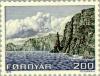
| X |
70o |
bl & blk |
Island of Sandoy Westcoast, p. 12.75 | |
|
|
| - |
80o |
yelbrn & bl |
Map of Northern Europe by Abraham Ortelius, p. 12.75 | |
|
|
| - |
90o |
brnred |
Map of Faroe Islands 1673, p. 12.75 | |
|
|
| - |
120o |
bl & dkbl |
Map of Northern Europe by Abraham Ortelius, p. 12.75 | |
|
|
| - |
200o |
bl & blk |
Island of Sandoy Westcoast, p. 12.75 | |
|
|
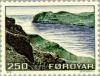
| - |
250o |
multi |
Islands of Streymoy & Vágar, p. 12.75 | |
|
|
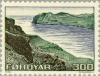
| - |
300o |
multi |
Islands of Streymoy & Vágar, p. 12.75 | |
|
|
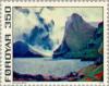
| - |
350o |
multi |
Islands Vidoy & Svinøy painting of Eyvindur Mohr | |
|
|
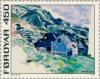
| - |
450o |
multi |
Village Nes painting by Ruth Smith 1913-1958 | |
|
|
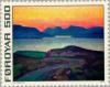
| - |
500o |
multi |
Headland Skálafjørður painting of Samuel Joensen-Mikines | |
|
|