StampData
Stamp catalog
Lists
Joint Issues
Sheets
Notes
Albums
Collections
Catalogs
Things
Tools
Statistics
Quiz
Login
Prev:
maps & coats of arms
Next:
Maps and Ships
maps & navigational instruments design type
Short desc: maps & navigational instruments
Used by 16 stamps:
(See all uses as list)
Marshall Islands 6/12/1984 1c issue=1984 d=Mili Atoll map & astrolabe perf=15x14
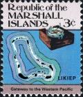
Marshall Islands 6/12/1984 3c issue=1984 d=Likiep map & azimuth compass perf=15x14
Marshall Islands 6/12/1984 5c issue=1984 d=Ebon map & old compass perf=15x14
Marshall Islands 6/12/1984 10c issue=1984 d=Jaluit map & anchor buoys perf=15x14
Marshall Islands 6/12/1984 13c issue=1984 d=Ailinginae Nocturnal perf=15x14
Marshall Islands 6/12/1984 14c issue=1984 d=map of Wotho & stick map perf=15x14
Marshall Islands 6/12/1984 20c issue=1984 d=map of Kwajalein & Ebeye stick chart perf=15x14
Marshall Islands 6/12/1984 22c issue=1984 d=map of Enewetak perf=15x14
Marshall Islands 6/12/1984 28c issue=1984 d=Ailinglaplap printed compass perf=15x14
Marshall Islands 6/12/1984 30c issue=1984 d=map of Majuro & navigational stick-chart perf=15x14
Marshall Islands 6/12/1984 33c issue=1984 d=map of Namu perf=15x14
Marshall Islands 12/19/1984 37c issue=1984 d=map of Rongelap & quadrant perf=15x14
Marshall Islands 6/12/1984 39c issue=1984 d=map of Taka & map of Utirk perf=15x14
Marshall Islands 6/12/1984 44c issue=1984 perf=15x14
Marshall Islands 6/12/1984 50c issue=1984 perf=15x14
Marshall Islands 6/12/1984 $1 issue=1984 d=Arno 16th cent sector compass perf=15x14